HGIS as a Tool for Studying and Doing Interdisciplinary Research on Past Environments: CUSP Examples
“Finding commonality in the archives”: Critical dendro-provenancing with Empire Trees Climate in Bermuda
“What does it mean to do interdisciplinary research on past environments?”
So asked Kirsten Greer, Adam Csank, and Margot Maddison MacFadyen in their Call for Papers for their special session at the 2017 American Association of Geographers’ (AAG) Annual Meeting. For the three scholars, who collaborated on the Empire Trees and Climate in the British North Atlantic project, including doing archival and dendrochronology fieldwork in Bermuda, doing interdisciplinary research on past environments meant “finding commonalities in the archives,” as recounted by fellow collaborator, Katie Hemsworth, in one of the required readings for this module:
Despite thinking of the archive in different ways – from the more traditional repository of historical records to political sites of cultural production to tree rings and pollen – the scholars were struck by the unexpected connections forged when they began to learn each other’s approaches.(Hemsworth, 2019)
Finding commonalities in the archive, which they also imagined as another type of “field,” meant stepping outside of their comfort zones. For example, Csank, a paleoclimatologist, brought historical geographer Greer along on tree coring pursuits as a research assistant. In those moments, Greer learned new methods and skills, gaining a new appreciation not just for the labour involved, but also for their shared commitment to understanding past environments to shape the future. When it came time for Csank to join Greer in the Bermuda Archives, his assumptions about the utility of archives for his research were challenged when he came across meteorological records that could be used to help reconstruct climates of the past, in conjunction with his tree ring and stable isotope data.
The Empire, Trees, and Climate fieldwork in Bermuda brought together several other scholars, all of whom had some interest in understanding past environments. Maddison-MacFadyen, an interdisciplinary scholar and writer, saw an opportunity to collaborate with Csank to better understand the colonial and environmental histories of a specific residence, called Cavendish, which was made with now-endangered Bermuda cedar. Beyond its connection to the histories of the British North Atlantic timber trade, Cavendish had indelible ties to another, intertwined trade: the histories of enslavement. One such connection was in Cavendish’s association with Bermuda National Hero, Mary Prince, the first known Black woman to escape West Indian enslavement and have her story preserved in written historical record (Prince, 1831).
Thus, another project emerged out of the larger one. Using archives, tree samples, and literary sources to “present an enhanced storytelling of Cavendish,” the team was better positioned to examine the environmental and material histories of colonialism, timber, enslavement, Emancipation, and abolition. As is often the case, their work led to the new avenue of inquiry: “How did emancipation affect timber flows?” A more detailed account can be found in Maddison-MacFadyen and Csank’s (2018) article listed in the required reading section of this module. You can also read more at Maddison-MacFadyen’s website about Mary Prince, which includes links to a historical junior fiction novella and other humanities outputs from her research.
HGIS as an interdisciplinary research tool
One of the challenges with interdisciplinary projects like Empire, Trees, and Climate is figuring out ways to store, manage, and synthesize research materials from very diverse sources. Digital methods played an obvious role in the capture, storage, and transportation of large swaths of primary source materials from the Bermuda Archives and tree samples from the surrounding landscape. Once back in Canada and the US, the collaborators were able to work across time and space with digital records, and put those into conversation with online data sets, including tree ring and geo-databases.
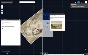
Beyond using digital tools for interpretation, perhaps the most important digital humanities approach was the use of historical GIS (HGIS) as an exploratory platform for georeferencing, geotagging, and storymappig past environments. The team turned to Megan (Prescott) Jee, a former Nipissing University student and GIS specialist who developed an extensive HGIS prototype that integrated collaborative research from across the humanities, social sciences, and sciences. The resulting storymap assembled a variety of digital texts and materials, including meteorological data, diaries, and 1960s bird recordings from the island. Acting both as a tool of inquiry and narration, the HGIS storymap continues to serve as a launching point for other researchers who might use the materials to inform future projects. To learn more and see the digital storymap, visit Empire Trees Climate via the CUSP Portal (Fig. 1). For an explanatory blog post on how Megan (Prescott) Jee approached the geotagging of historical images, see “Geotagging Images Then and Now.”
A Global Tradition: Historical Geographies of McGill University’s Field Stations
The second HGIS storymap example, “A Global Tradition: Historical Geographies of McGill’s Field Stations,” highlights multiple layers of interdisciplinarity through an in-depth exploration of the historical geographies of McGill University’s field research stations in the 1950s-70s. These many layers, and the stories they tell together, are best appreciated by visiting and interacting with the storymap using the link provided above. Given that this is an educational platform that uses interactive maps and databases with no expectation that users will have the same training, another contribution of the module is that it offers navigational tours of the interface, an example of which can be found here.
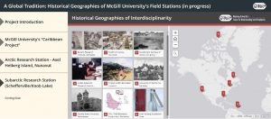
Perhaps most notably, the project shows how interdisciplinary tools and approaches of HGIS can also be harnessed to narrate the histories ofinterdisciplinary research. It does so by incorporating primary and secondary source materials from existing research on the field stations in an interactive format. The platform provides a digital repository that can be used to showcase other scholarly outputs such as academic publications and presentations related to the projects. A Global Tradition features partnerships between scholars in geography and history departments at Nipissing University, Queen’s University, McGill University, as well as McGill’s Rare Books and Special Collections and Canada Museum of Science and Technology (Fig. 2).
The storymap features ongoing research and should be viewed as dynamic, partial, and situated, continually updating and taking new shape as more research gets integrated. A Global Tradition focuses on the establishment of three of McGill’s field stations in the 1950s-1970s, including:
1. Humid Tropics Research Stations (The “Caribbean Project”, Barbados)
2. High Arctic Research Station (Axel Heiberg Island, Nunavut)
3. Subarctic Research Station (Schefferville/Knob Lake, Quebec, in progress)
Founded by the Department of Geography in Montreal, the above research stations served as sites of collaboration by scholars and students in climatology, biogeography, historical geography, glaciology, and geomorphology. The module situates environmental research within local, regional, and global context through many different forms of media, including excerpts from related publications mapping the historical relationship between scientific and environmental knowledge production and Cold War geopolitics of the time.
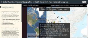
As the introduction explains, scholars are increasingly recognizing the value of incorporating interdisciplinary approaches to address the challenges of global environmental change. However, the histories of interdisciplinary research projects, like those coming out of McGill’s research stations in the 1950s-70s, remain under-examined. The researchers therefore ask:
What do these research stations tell us about the histories of interdisciplinarity in (geographical) research, and how can we use these stories to be more reflexive of our own traditions in global environmental research?
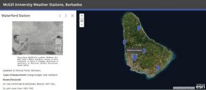
As the second objective in Figure 3 alludes, HGIS offers the capacity to showcase these interdisciplinary histories of climate research. Although the storymap features distinct submodules that can be accessed separately (for example, users can click on the “Caribbean Project” to focus more on the Humid Tropics research stations seen in Fig. 4), their assemblage in one “place” accentuates the mobilities and interconnectedness of the stations as well as the institutions, landscapes, people, and instruments of environmental research.
The submodule about the Axel Heiberg Island station, for example, documents the historical geographies of not just interdisciplinarybut also international collaboration, and includes stories from researchers who worked at more than one McGill research station. These interconnections were highlighted through the careful layering of a plethora of digitized materials about the early research expeditions, including reports, maps, satellite and aerial photo imagery, fieldnotes, photographs, and even a video about the 1960 expedition to the island.
Such materials, and their display through HGIS, tell stories about international and multi-institutional partnerships. This includes collaborations between Canadian-based researchers and Swiss glaciologists like Fritz Müller, a former McGill student and one of the founders of the White Glacier Program and the High Arctic Research Station, whose legacy included the detailed glacial-mapping of the Arctic region (Adams, 2000). Audio excerpts of interviews conducted in Switzerland by Queen’s University collaborators with some of the remaining members of the 1960s expeditions, as well as short films, will also be added as the research evolves. In addition to sharing digital humanities research materials like digitized audio interviews, videos, and archival photographs (and providing the main source of funding for the project), the Queen’s University team brings another important interdisciplinary contribution: collecting geospatial and glaciological data through their ongoing, in situ research on Axel Heiberg Island, which both uses and inputs data in the Polar Data Catalogue mentioned in the Spatial Archives module.
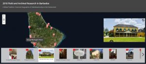
As we wrote at the start of this section, the stories presented through A Global Tradition highlight many different themes of interdisciplinarity, including but not limited to: 1) the interdisciplinary methods and knowledges used to create the HGIS storymap and 2) the histories of interdisciplinarity and international collaboration. Another, often-overlooked, capacity is the 3) ability to “map out” research in progress, which might involve documenting (spatially) the geographies of a given project that allow researchers to geolocate their own research travels, which might also lead to greater reflection on their own mobilities and impacts. Although we have not yet explored this latter potential in explicit detail for this specific storymap, using GIS to map the spatialities of our own fieldwork may be a start. This is evident in the “2018 Field and Archival Research in Barbados” layer (Fig. 5), which uses ESRI’s Tour Story Map tool to geolocate, visualize, and narrate fieldwork through geotagged photographs.
