Creative Geovisualization
Creative geovisualization is many things: a process, a method, an output, a field, an art form, and a collaborative practice. It includes critical GIS as well as other geospatial forms of digital art-creation. As Jin-Kyu Jung (2020: 520) writes,
Creative GIS and geovisualization are situated at the intersection of critical, qualitative, and affective forms of GIS, geography, arts, and digital humanities with a particular emphasis on visualization and mapping. Creative geovisualization presents innovative ways not only to describe geometric space, but also to imagine and create personal, qualitative, artistic, and humanistic experiential, interpretive, and expressive visual representation.
Creative geovisualization might therefore be considered a form of deep mapping (Bodenhamer et al., 2013), not only preserving and representing, but also generatingmore nuanced and contextual meanings of place (Jung, 2020). The affective, performative characteristics of geovisualization highlight the “more-than-representational” possibilities of art-creation (Lorimer, 2005); that is, the ability for creative geovisualization to not only represent spatial relationships but to actively evoke and create space in an ongoing process of (re-)building.
Of course, all GIS incorporate artistic elements and reflect the creativity of users, but an arts-based approach involves more explicitly welcoming emotional and affective elements into the research design from the outset. Indeed, the uptake of “emotional mapping” as critical geospatial arts practice shows yet another example of the creative expansion of GIS and geovisualization over the past two decades (Jung, 2020). Critical and cultural turns within the spatial humanities has inspired critical-historical GIS projects that are increasingly embracing the creative, the playful, the experimental, the uncertain, and the imaginative. These turns have marked a shift toward subjective, qualitative, and embodied knowledges of place (Jung, 2020).
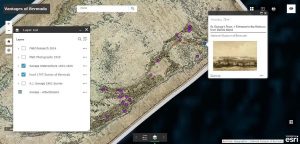
Although we focus more on “more-than-visual” projects of geospatial art-creation in this module, one example of creative geovisualization coming out of Nipissing University can be found in the “Vantages of Bermuda” layer of the Empire Trees Climate storymapping project (led by Kirsten Greer and designed by Megan Prescott Jee). Jee used HGIS storymapping apps to not only display visual art (such as watercolour paintings from 1830s) but also to georeference it, and to use art as a launching point for understanding different geographical “vantages” that could help reconstruct the past. Working with the research team to locate and digitize historical maps and watercolour landscape paintings, Jee obtained satellite imagery which contained geocoordinates, using all of these materials to georeference and then geotag notable points on the map (Fig. 1).
The Vantages of Bermuda layers highlight the generative potential of creative geovisualization. In this case, artistic and historical materials (paintings and archival maps, for example) simultaneously helped researchers re-construct past places while geospatial tools like georeferencing and GIS facilitated the preservation and re-interpretation of historical artwork. To learn more, visit “Vantages of Bermuda” on the CUSP portal.
Guiding features of creative geovisualization
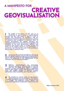
Creative geovisualization practices are highly varied and should not be reduced to generalizations. However, attentiveness to the unifying qualities that underscore creative GIS and geovisualization is also useful for developing methodological and ethical guides that can be used as research and pedagogical tools across the digital spatial humanities. Such resources are often shared through online scholarly and geospatial arts communities. One example is an open-access “manifesto” poster shared by Phil Nicholson (2019), an output of his PhD research which involved theorizing, practicing, and mobilizing creative geovisualization:
The field of creative geovisualization, as the poster in Fig. 2 suggests, involves taking considerable care to understand the historical, affective, collaborative, and more-than-representational potential of using geospatial practices. This includes, for example: mindfulness of the histories of GIS, incorporating emotional and affective elements more directly into the research design (as an intention rather than simply an outcome), embracing interdisciplinarity and remaining aware of the challenges that arise, and being attentive to “creative modes of representation and performative acts of information” (Nicholson, 2019).
Changing Displays, Reorienting Sites
Creative geovisualization builds and extends spaces that were previously more confined to a physical location. One example we have already seen in the Digital History module is the use of geospatial technologies like locational apps, GPS, GIS, and 360 cameras to reimagine and extend the spatialities of GLAMs (galleries, libraries, archives and museums). Creative geovisualization is therefore not only a means through which to share and respatialize historical and geographical knowledges but can also be used to reimagine the sites, spaces, audiences, and displaysthrough which such stories are mediated. Indeed, sites of artistic “display” in the digital context can shift dynamically from the museum to the computer screen to the body, shaped by both physical and digital parameters.
GLAMs are by no means the only sites of cultural knowledge production, but they are some of the first places that come to mind when thinking about the sites through which art, memory, heritage, and place overlap. Digital technologies have, however, reoriented how artists engage with what Kwon calls “site specificity,” shifting from preoccupation with physical locations toward “a discursive vector – ungrounded, fluid, virtual,” and in doing so challenges the sense of site as static (Kwon, 2002: 1; see also Hawkins, 2013). Some artists, however, have also embraced the digital as a method of re-engaging site specificity through tools like geotagging that re-root the seemingly globalizing, placeless, and ephemeral characteristics of digital space. These changing spatial engagements with site raise new questions about creative interplays of space and scale, from the embodied to the ephemeral, the material to the digital, and from the local to the global.
