Geographical “Traditions”
Historical mapping and spatial archives
In module 3, we discussed the historical power relations that shape archives and other GLAM collections, with a specific focus on the colonial and imperial histories of mapping. In a similar vein, spatial storytelling in the digital humanities benefits from an understanding of historical power relations that produced spatial archives, or archives that primarily house and manage geographical materials. This course focuses primarily on histories of mapping, cartography, and spatial archives in colonial and settler colonial contexts, but it is important to note that mapping has occurred in different forms for much longer.
It is well documented that maps have been weaponized for colonial and imperial projects that have led to the displacement and genocide of Indigenous peoples across the world (Goeman, 2013; Harley, 1992; Hunt and Stevenson, 2017; Said 1992; Sparke, 1998). However, Indigenous scholars (and scholars of settler colonial histories) also challenge the exclusion of Indigenous knowledges from academic histories of geographical practices like mapping, given that spatial knowledges, tools, and media have long been part of Indigenous practices. Examples include birchbark migration charts, songs and songlines, oral histories, pictographs, petroglyphs, dance, dreams, wampum belts, which were largely excluded from Eurocentric conceptualizations of “mapping.” However, these practices have long been used to communicate important navigational and other spatial knowledges such as place names (toponymy), directions, migrations, ancestral territories, relationships, and trade routes. All of these geographical engagements, which are still practiced today and interwoven with digital technologies, challenge the notion of mapping as a purely colonial practice, raising critical questions about what might exactly is meant by “traditional” in the context of mapping and spatial archives.
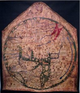
Other early examples of mapping include ancient and medieval maps in printed chart or cloth form, including the European maps of the world broadly categorized by the Latin term, mappa mundi. These maps often used a tripartite “T-O” structure (the T dividing the circular O of the world into three known continents) and were not intended as navigational charts. Instead, they communicated themes and principles such as climate zones, “known” land masses, and groups of people. Medieval maps tended to be produced for national and religious propaganda that furthered racist accounts of “othered” people and places through depictions of deformity and monstrosity (Nock 2001).
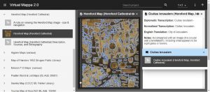
One example of a large-scale digital humanities project that works with mappa mundi is “Virtual Mappa”Project(Fig. 3) offered through the Digital Mappa platform, developed in 2009-2010 (Foys and Bradshaw, 2011). Virtual Mappa was created as “an ongoing set of networked digital editions of medieval maps, published as open access scholarship, and undertaken in collaboration with the British Library, and hosted by the Schoenberg Institute for Manuscript Studies” (Virtual Mappa, 2020). To view and work with the annotated maps, visit the Virtual Mappa platform.
Many of the cartographic efforts that we now understand as extensions of Empire (using maps to exercise “remote control”) or as tools of colonial projects came out of the Renaissance era of the 14th to 17th centuries, often called the “Age of Discovery” or the “Age of Exploration.” Yet discourses of “discovery”and “exploration” obscure the very important fact that newly mapped places were never previously “empty” spaces, as the maps might suggest. Several expeditions occurred during this time period that resulted in the charting of places like Australia and the Americas. This included efforts of circumnavigation of Australia, called New Holland by Dutch cartographers, which was previously thought to be connected to an imagined south continent written onto maps as Terra Australis, or Australia for short (the name was later transferred to what is currently known as Australia). Moving into the Enlightenment era (17th and 18th centuries), Portuguese and British colonizers were particularly determined to map India and Africa, starting with the coastlines to facilitate traders’ access via sea routes, and then moving inland to document rivers and cultural characteristics.
During the age of Empiricism, in the 18th and 19th centuries, maps shifted from being used primarily as tools of commerce and trade to tools of control and settlement. Further advancements in transportation, collecting, and record-keeping technologies enabled a greater degree of accuracy, or a greater projectionofaccuracy, of places mapped throughout this period. These efforts occurred alongside the rapid construction of cultural institutions (including archives, museums, and universities) staking claims to land, knowledge, and power. In addition to projects of imperialism and colonialism, maps became particularly useful for 19th century projects of settler colonialism (Hunt and Stevenson, 2017; Veracini, 2011).
Tuck et al. (2014: 6) describe settler colonialism as a “form of colonization in which outsiders come to land inhabited by Indigenous peoples and claim it as their own new home.” Although often intertwined, Veracini pinpoints an important distinction between colonialism and settler colonialism, stating: “…whereas colonialism reinforces the distinction between colony and metropole, settler colonialism erases it.” (Veracini 2011). As we have seen in previous examples, both colonial and settler colonial maps have the ability to erase; however, Veracini’s point is important for considering how maps erased, silenced, or displaced in different ways depending on the objective. For settler colonialism, mapping was used to carve out space for settler powers, economies, and people, often making it seem as though they were always there. The people and institutions with the power to create the maps also had the power to alter boundaries, force homogenization of diverse groups and lands, and disguise land encroachment with the mere drawing of a line. Settler colonial maps, therefore, involved the re-writing and re-mapping of places that already had their own layered cartographies, which was all done in concert with the de-legitimizing of Indigenous and other subordinated knowledges.
The social costs of colonial mapping and collecting for spatial archives must always be part of the reflexive process when analyzing and using maps for digital humanities research. As we have discussed throughout the course, any use of spatial archival materials must be done with care and with an understanding of the historical contexts that shaped their creation and preservation, to avoid reproducing the harms of (settler) colonial relations. In the latter half of the course we will examine how colonial devices like maps and spatial archives are being countered and re-imagined for social change.
Locating Colonial Spatial Collections in the Past and Present
As we discussed in the previous module, collecting and housing collections were central practices of the colonial-geographic tradition (Livingstone, 1992). Where were some of the colonial collections housed, and where can we find them today? These are important questions for digital humanities researchers seeking to work with physical and digitized spatial materials, such as maps and spatial statistics of different time periods. In this section, we locate and historicize some brief examples of geospatial collections.
The Colonial Office, Royal Commonwealth Society, and the Blue Books
Established as a British government department during the 18th century to manage the colonial affairs of British North America, the Colonial Office solicited and housed a plethora of place-based information and materials from across the colonies. As such, they can be considered historical examples of colonial spatial archives or libraries. Throughout the 19th century, the Colonial Office took various forms as the War and Colonial Office (1801-1854), and later the Second Colonial Office (1854-1966), which included a Dominion Division that was formed to track the increasingly independent Dominions (Canada, Newfoundland, Australia, New Zealand, and South Africa). In 1968 Britain joined all offices of external relations into the Foreign and Commonwealth Office (Foulds, 2006).
Perhaps the most significant resource of spatial media that came out of the Colonial Office, and later into the Royal Commonwealth Society (1868-2018), were the colonial Blue Books. These books, or collections of materials, were assemblages of colonial maps and other spatial and statistical data that contained information about taxes, population, trade, military, public works, schools, and prisons, among others. As Sarah Preston (2007) explains, the content of each book varied greatly across the colony, depending on the place and the individual filling it out. Books included a “watercolour of native plants” (Ghana, 1858), “coloured maps of the island and street plans of its principal towns” (Malta, 1823), swatches of cotton cloth, and ground plans of carceral institutions.
![Scanned image of the title page of an Arctic Expeditions report held in a Blue Book, titled 'Report of the Committee Appointed by the Lords Commissioners of the Admiralty to Inquire and Report on the Recent Arctic Expeditions in Search of Sir John Franklin, [description continues], 1851'](https://ecampusontario.pressbooks.pub/app/uploads/sites/2418/2022/02/mod4fig4-171x300.jpg)
Having recently acquired the library and archive collections of the Royal Commonwealth Society, the Cambridge University Library now houses a large collection of original Blue Books. However, other copies can be found across the world, including the Arctic Blue Books at the University of Manitoba Libraries, Archives & Special Collections (A2002-035).
Recent digitization efforts have opened access to vast primary source materials that can be put into conversation with other materials and knowledges to understand the past in a new or brighter light. Indeed, the physical and digital books continue to be used for all kinds of research projects, including those across the digital spatial humanities, including HGIS research on the historical geographies of the British North Atlantic at Nipissing University’s Centre for Understanding Semi-Peripheries Portal.
Royal Geographical Society (1830-)
Another 19th century place that highlights how spatial archives are inseparable from the histories of Empire and colonial rule, and which has undertaken a massive effort to digitize geographical materials, is the Royal Geographical Society (RGS) in London, UK. Founded in 1830 and originally called the Geographical Society of London, the society later became the Royal Geographical Society under the patronage of King William IV. The RGS was designed “to promote the advancement of geographical science,” which included playing a central role in British colonial exploration of Africa, Asia, the Indian subcontinent, and polar regions of the world (RGS.org). The building became a site for the housing and management of the materials required to document and claim place – maps, surveying instruments, and other spatial texts, including collections from well-known explorers, geographers, scientists, anthropologists, and missionaries. These included such famous figures as Charles Darwin, David Livingstone, and Edmund Hillary – many of whom occupied multiple disciplines.
The Society, now joined with the Institute of British Geographers (IBG), currently has one of the largest private collections of maps and atlases in the world, including materials printed over 500 years ago (the oldest printed cartographic item in their collections dates back to 1485). In addition to maps and atlases, the RGS Collections include other spatial materials such as artefacts (cultural objects and exploration paraphernalia), books and pamphlets on the history and geography of places worldwide, manuscripts and journals (geographical research publications and biographies of 19th and 20th century travelers and geographers), photographs and artworks (over half a million items), expedition reports (held on their Expeditions Database), and films (now fully digitized and available through the British Film Institute Player).
As Wiley Digital Archives shows in the video, “Inside the archives of the Royal Geographical Society (with IBG)“, managing collections of historic maps and other geographical materials takes considerable effort (Wiley, 2019). The acquisition and archiving of old maps, for example, follow several complex steps; they must be assessed for condition, sent for repair if necessary, carefully packed up and transported to an off-site location, scanned, digitized, uploaded, and eventually returned to the collection. It is worth considering how (or whether) the materialities and meanings of a map change throughout this multi-step process, and particularly during digitization. Some questions to ponder as we move further into digital spatial storytelling include:
- What is lost and gained through digitization?
- What new kinds of stories and storytellers might digitization enable?
- How does digitization of these spatial archives address the histories of representation and under-representation of particular places, people, and knowledges?
- How might digitized collections of geospatial materials be used to document, resist, or better contextualize colonial and imperial histories?
We encourage you to reflect on these questions throughout the course, and we will discuss them more directly in later modules (for example, when we discuss digital counter-mapping as one branch of digital storytelling). As we transition into a discussion of digital spatial archives and digital humanities research materials, we will first consider other kinds of archival spaces that further ignite – or challenge – the archival imagination: more-than-human archives and the climate proxies they might produce.
