4.4 International Transport Network
Learning Objectives
Now that you know the modes of transportation in detail, it would be beneficial to analyze international transport networks. The International Transport Networks consist of shipping routes worldwide and container ports connecting many countries and continents for moving freight.
Video: Marine Traffic – A Visualization of Global Shipping Data (1:49)
Unsigned created custom software to produce a film showcasing the data in a new visual format.
Media 4.2 Marine Traffic – A Visualisation of Global Shipping Data [Video]. Aurecon. (URL: https://www.youtube.com/watch?v=JLg1_dnWXR8)
Routes include the Trans Mongolian and Trans-Siberian railways as well as Northern Sea and Commercial Maritime routes and Air Freight Hub (Mangan & Lalwani, 2016, p.114).
Northern Sea Route
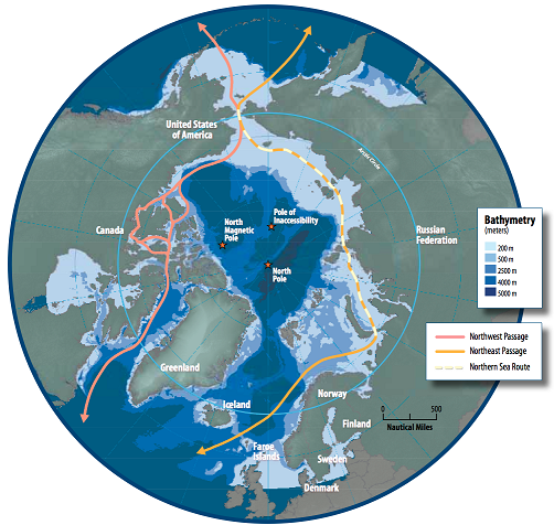
Note. From Harder, 2009). Arctic Council Public Domain. [Image description].
- The Northern Sea Route (NSR): NSR opened new doors for international trades in containerized goods and connected Asia with Europe, Russia, with Korea. According to a journal about the Northern Sea Route (2020), this channel reduces distance by up to 40% between Europe and Asia (Khazheeva & Bondarchuk, 2021). The Northern Sea Route (NSR) gradually creates opportunities for shipping companies and moves freight faster by using short distances between destinations. Because of global climate change and melting icebergs in the Arctic. The research found (2020) that climate change impacts the ship schedules and sizes of vessels, which should have particular metal for moving through ice. In addition, the lack of modern deep-water ports and shipping small cargoes is sophisticated for this route (Keltto & Su-Han, 2020).
- Trans-Siberian railway is a part of international transport corridors (ITCs) and has the longest railway in Russia, which interconnects the Far East and the European Union ports. This channel generates economic cooperation between countries, world trade, the well-being of countries’ population, infrastructure, and opens huge sales markets for domestic companies within countries (Khazheeva & Bondarchuk, 2021).
- The least expensive cost and volatile region shipping through the Suez Canal and between Europe and Asia. The Suez Canal/ Panama is the most changeable region in the world and has vessel canal restrictions. At the same time, Northern Sea Routes and Trans-Siberian Railway are the second options of shipping cargo and are more expensive (Mangan & Lalwani, 2016, p.114).
- Trans-Mongolian Route starts from Moscow and finishes in Beijing. Trans-Siberian Route – Vladivostok and St. Petersburg. Destinations in both routes take approximately six days (Richmond, Bloom, Duca, Haywood, Kohn, Low, Masters, McCrohan, St. Lous., & Vorhees, 2015).
Figure 4.5
International Transport Network
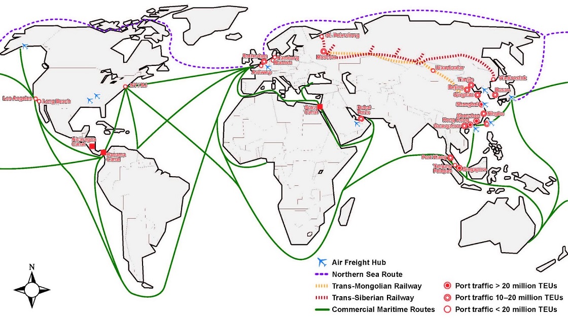
Note. [Image description].
A consignor can choose any carrier organization because many global shipping companies move freight over broadly similar routes. The significant difference will be related to cost and time. The vital key role in deciding the freight shipment is the cost factor.
New routes are planned and emerge globally, such as the Nicaragua Canal and the Northern Sea Route (Mangan & Lalwani, 2016, p.114). Shipping channels can significantly impact global economic integration, export service, and world seaborne trade and help less economically developed regions stimulate foreign trade (Chen, Notteboom, Liu, Yu, Nikitakos, & Chen, 2019). The Nicaragua Canal will connect the Caribbean Sea with the Pacific Ocean to compete with the Panama Canal (Chen, Notteboom, Liu, Yu, Nikitakos, & Chen, 2019). Also, the Nicaragua Canal can accommodate much more enormous vessels than the Panama Canal because of the superior water depth, which is a minimum of 26.9-29.0 m (Chen, Notteboom, Liu, Yu, Nikitakos, & Chen, 2019). According to the article “The Nicaragua Canal: potential impact on international shipping and its attendant challenges” (2019), the potential of the Nicaragua Canal is significant because it can impact developing port’ systems in the Pacific and the Atlantic Oceans and create a cargo channel to Cuba, Venezuela, Colombia and other regions (Chen, Notteboom, Liu, Yu, Nikitakos, & Chen, 2019).
Check Your Understanding
Describe the international transport network.
Answer the question(s) below to see how well you understand the topics covered above. You can retake it an unlimited number of times.
Use this quiz to check your understanding and decide whether to (1) study the previous section further or (2) move on to the next section.
Interactive activity unavailable in this format
Text-based alternative to interactive activity available in Chapter 4.7.
Overall Activity Feedback
Now that you know the modes of transportation in detail, it would be beneficial to analyze international transport networks. The international Transport Networks consist of shipping routes worldwide and container ports connecting many countries and continents for moving freight. A consignor can choose any carrier organization because many global shipping companies move freight over broadly similar routes. The significant difference will be related to cost and time. The vital key role in deciding the freight shipment is the cost factor.
Media Attributions and References
Aurecon. (2018, March 5). Marine traffic – A visualisation of global shipping data. [Video]. YouTube. https://www.youtube.com/watch?v=JLg1_dnWXR8
Harder, S. (2009). Arctic marine shipping assessment [Image]. Arctic Council. https://commons.wikimedia.org/w/index.php?curid=36253405. Public Domain.
