2.9 The Railway
Completing the Intercolonial Railway between the original four provinces was a condition of Confederation. That task could be accomplished without too much difficulty. After all, the colonies had laid some 3,200 km of track by 1865. Finding a company with the wherewithal to build a railway from Montreal to the Pacific was a whole different order of magnitude. The Grand Trunk Railway was the obvious candidate but its directors balked at the prospect of an all-Canadian route. The newly-established Canadian Pacific Railway (CPR) was a contender in 1873, but that plan ran off the proverbial rails when it was discovered that Macdonald’s Conservative Party had received significant funds from the CPR. The Pacific Scandal cost Macdonald his administration, brought the Mackenzie Liberals into office, and a substitute railway company could not be found. The Mackenzie administration was not without accomplishments in this regard: in one term of office it oversaw the construction of several north-south lines that would assist Canadian exports. Returned in 1878, and faced with an almost apoplectic British Columbian body politic that was calling for “The terms [of union], the whole terms, and nothing but the terms,” Macdonald resumed the search for a contractor. Again, the CPR stepped forward and the project, started in 1880, was completed in a remarkable six years. Built with heavy government subsidies and other incentives provided to the CPR Company, it represented a genuine engineering achievement. It was also a massive corporate accomplishment.
The CPR as Land Baron
The legal mechanism that made possible the distribution of western lands was the Dominion Lands Act of 1872, aspects of which were highly problematic. For one, it disregarded Aboriginal title in violation of treaty agreements. Aboriginal peoples continue to protest this situation. The Act had implications, too, for the provinces of the West. Nova Scotia, New Brunswick, Ontario, and Quebec (and, a little later, PEI) all had exclusive control over their natural resources (with a few exceptions like fisheries), but land and other natural resources across the whole of the Prairie West and the Peace District in northeastern British Columbia were Ottawa’s to control, tax, and dispense. Establishing settlers increased traffic on the railway. This increased the movement of supplies and farm equipment from east to west, it stimulated steel production in the original provinces, and as capital and sweat were invested in farms, it created a market for land and further revenues for the state. Ottawa became wealthy on western lands while western territories and provinces did not. Finally, the parceling out of western lands in sections determined a human geography on the plains that was brutally rigid. Roads were driven at one- or two-mile intervals that corresponded with the grid of sections. The effect was to separate neighbours by miles of landscape and to leave settlers’ access to fresh water and woodlots up to chance. Community and sustainability, however, were not concerns of the CPR or the Lands Act.
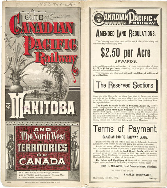
One way of speeding along the process of commodification of land involved the CPR very directly. A mammoth swath of territory on either side of the railway right-of-way — 25 million acres (roughly 10 million hectares) — was granted to the CPR as an incentive. Inevitably, this was considered some of the most desirable land on the Prairies because proximity to a railway station was critically important to the financial viability of a wheat farm in the days before gasoline-powered trucks. The CPR quickly became an integrated corporation, consisting of passenger/freight transportation, communications, and land sales (at $2.50 an acre) combined with a recruitment and marketing arm that aimed to lure Canadians and immigrants into the West. The CPR even purchased a fleet of vessels to ship settlers across the Atlantic, and built another to extend its reach across the Pacific to Asia.
The gallows in Regina were barely cleared off following the events of 1885 when the CPR moved into an entirely unforeseen enterprise: the hotel and tourism business. After he became president of the railway in 1888, William Cornelius Van Horne (1843-1915) sought to capitalize on the growing market for travel by promoting the exploration of the Victorian version of the wilderness in comfort, in a specially designed sleeping car. “If we can’t export the scenery, we’ll import the tourists,” he is reported to have announced.[1] The company erected imposing structures like Glacier House near Rogers Pass, Mount Stephen House at Field (both opening in 1886), Fraser Canyon House at North Bend (1887), and the Banff Springs Hotel (1888), even before turning its attention to the monumental hot springs hotel at Banff. Some of these were modeled on hunting lodges, some on European chateaus, and all of them were an expression of the CPR’s role as an extension of North Atlantic civilization’s values, economy, and systems.
Routes to the Pacific
The CPR’s route across the West, from Ontario to the Pacific Coast, is one of the sharpest points in the history of the early Dominion. As the initial infrastructural, administrative, and economic extension of Canada, it had (and continues to have) a powerful influence on many aspects of life.
The most critical decision in routing was made at the very outset. Chicago had already emerged in the 1870s as the leading transportation hub in the interior of North America. It was possible to ship goods without interruption from western Ontario via Lakes Huron, Superior, and Michigan, directly to the Illinois port. What’s more, Chicago had established its primacy in railway transportation as well. One option open to the Canadians was, therefore, to build a route across southern Michigan to Chicago and then north to Manitoba. The cost would be a fraction of any all-Canadian route, but it exposed an important national link to unpredictable relations with the United States. Canada, after all, had been founded with the threat of American invasion in mind; if defending the West against American expansionism was one reason for (a) annexing Rupert’s Land in the first place, and (b) building infrastructure that would enable the quick movement of troops, then it made no sense to stake all of that on a railway that passed through American territory.
That meant shifting the route north across the Canadian Shield. The Shield contained some of the most difficult terrain that surveyors and engineers encountered, and that includes the Rocky Mountain passes. The Shield slowed down construction and ramped up costs exponentially. It also frightened off investors, particularly those in the United States.
Ottawa responded with lucrative incentives to the Canadian Pacific Railway Company of Montreal. The CPR, under the leadership of Sir Hugh Allen (1810-1882), replied with gifts of money to the Conservative Party in 1872. These donations — totaling approximately $350,000 — were exposed in April 1873 in what became known as the Pacific Scandal. John A. Macdonald’s government began to topple. By the autumn — coinciding with the Panic of ’73 (a financial crisis that gripped the United States and was related directly to overbuilding of railways) — Macdonald’s position was irretrievable. An election in January 1874 saw the Liberals, under Alexander Mackenzie, form a government for the first time. The economic situation was poor, however, as was Mackenzie’s timing.
The Liberals put their trust in the Department of Public Works and Sandford Fleming (1827-1915), a civil engineer (and the inventor of worldwide standard time) who surveyed and approved a route through the Yellowhead Pass in 1872. The northern route would head off from Winnipeg to the Saskatchewan River Valley, and thence to Fort Edmonton and the north-central Rockies. Beyond there, the most promising option seemed to be through the Cariboo to Bute Inlet, across Seymour Narrows (at what is now Campbell River), and south to Esquimalt.
The northern route presented several advantages, the first of which was the agricultural potential of the territory through which it passed. The Saskatchewan River Valley and the parklands of the central Prairies contain good water and soil resources, and they are well-treed — an asset from a log-house building perspective and with regard to fuel. This was a sharp contrast with the more arid lands of Assiniboia, which included Palliser’s Triangle, an area of poorer, brown soils that stretches, roughly speaking, along the 49th parallel from what is now mid-Saskatchewan to Lethbridge in the west and Drumheller in the north. Crossing the Rockies was going to present a challenge whichever direction was chosen, but from a farm economy perspective the northwestern route seemed the logical choice. Certainly the earliest settlers thought so. Métis who were displaced in Manitoba headed into the region, while country born and Canadian migrants formed nodes of their own, drawn by early promises of railway connection with the CPR. These small but well-established settlements were, however, an obstacle when it came to finding sufficiently lucrative land for the CPR’s grant.
The company opted in 1881 for the southern route instead, heading more or less straight across the Prairies from Winnipeg to Banff and the Kicking Horse Pass. As historian of Saskatchewan, Bill Waiser, notes:
This decision, one of the most controversial in western Canadian history, completely changed the axis of development in the region by focusing attention on the southern prairies — the North-West effectively became the west. In the process, the future province of Saskatchewan became associated in Canadian minds with the flat, treeless prairie.”[2]
As well, the southern route meant that the most intensively farmed lands were located in an arid belt that would generate environmental and economic tragedy in the 20th century (see Section 8.5).
The southern route had repercussions in British Columbia as well. The Bute Inlet to Victoria route was swept away by Macdonald when the Conservatives returned to power. Instead, the CPR terminus would be located in Port Moody, a milltown at the head of Burrard Inlet. As a kind of consolation, and in recognition of the commitment made in 1871 regarding a railway to Victoria, the Esquimalt & Nanaimo Railway (the E&N) was built by coal magnate Robert Dunsmuir to connect his mining operations at mid-island with the capital. Each of these changes improved the CPR’s position as a real estate company. Each of these changes embittered local farmers, investors, speculators, Indigenous peoples, and the Métis, who saw the CPR seize the most profitable land and determine where the biggest cities were going to go — all while abandoning whole communities.

Gastown to Granville
Nowhere was the city-building ambitions of the CPR clearer than along Burrard Inlet. On both the north and south shore of the fjord there had been logging operations in play since the 1850s. The largest and oldest of these, Moodyville (named for Sewell Moody, an American entrepreneur), was located on the north shore and was a poor candidate for a rail terminus from the east. At the head of the inlet was Port Moody (named for Colonel Richard Clement Moody, a Royal Engineer and Lieutenant-Governor of BC), which enjoyed good access to the mostly level Fraser Valley. This made Port Moody a prime choice for the CPR. The challenge facing the company was that speculators had reached Burrard Inlet first, buying up much of Port Moody in the hope of being bought out by the CPR at a handsome profit. Actual railway construction heading east began here and the town was, officially, the terminus until the line was finally completed. Shortly thereafter, in 1886, a devastating fire destroyed a third of Hastings Mill and its commercial area (known officially as Granville and unofficially as Gastown). The largely flat landscape was almost completely denuded of trees and stumps (as well as almost all of its building stock). The CPR announced a change of plans and extended the line from Port Moody another 24 km west, to a vast new land grant in the newly incorporated city of Vancouver. The recently-logged West Side of Vancouver was entirely within the company’s grant, while the shattered and recovering parts of Granville now constituted the East End. The move bifurcated the community, an event that is manifest to this day in wealth on the West Side, poverty on the East, and street misalignments in the middle.
Describing the many ways in which the CPR and its later competitors changed the landscape, demographics, resource exploitation, economy, and townsites still merely scrapes the surface. Behind the CPR was not only a political network but also a dense web of interlocked commercial and financial boards. Directors of the CPR also sat on the boards of the Royal Bank, Dominion Bridge, Dominion Iron and Steel, and international oil companies (see Section 8.3). Donald Smith (later styled “Lord Strathcona and Mount Royal”) was not only president of the Bank of Montreal but an influential Conservative Member of Parliament for Montreal. The intersection of Hastings and Granville Streets in Vancouver provide a physical manifestation of the extent of this influence. On one corner, there was the Bank of Montreal, opposite it the Bank of Commerce, across Granville there were the offices of the federal government, and just down the hill facing the water was (and is) the CPR station itself.
Key Points
- The Canadian Pacific Railway was both a unifying and divisive instrument of Canadian expansion.
- The decision to change to a southern route created hardships in the north-central plains.
- The CPR operated as a railway and construction company, as well as a land dealer and hotel operator. It was, as well, closely linked to the Bank of Montreal and so was integrated with many other corporations.
- The choice of routes had significant impacts on the West Coast, where Vancouver was eventually selected as the site for the terminus, leaving both Port Moody and Victoria disappointed.
Attributions
Figure 2.16
Land ticket by Will Jahns is in the public domain.
Figure 2.17
Str P8 – [Water Street looking east] (Reference Code: AM54-S4-: Str P8) by City of Vancouver Archives is in the public domain.
