1 CMB 1 – Burleigh Falls
Heidi Daxberger and Phillip Ruscica
GPS Coordinates (44°33’20.88″N, 78°12’12.32″W)
Parking: Public (paid) parking is available on the North West side of the bridge across the Stoney Lake at HW 28.
Burleigh Falls (CMB 1) is located about 30 km north west of Peterborough (HW 28). Glacially smoothed and scoured outcrops can be found on both, the North and South side of the narrow passage across the East-West trending Stoney Lake.
Click here to open the bedrock geology legend on the OGS website
The Digital Outcrops
The virtual 3D models show portions of the outcrop to the South East of the Stoney Lake bridge (HW 28). The first model shows the road cut outcrop along the East side of HW 28 which measures about 4 meters in length and about 2 meters in height. The weathered rocks seen in birds eye view from the top of the outcrop show the well developed and characteristic gneissic banding of the rocks at Burleigh Falls. The fresher rock surfaces along the edge of the road cut (side view) enables the determination of the composition of the Burleigh Falls gneisses, which vary from granitic to amphibolitic gneisses depending on the sections of the outcrop. The age of these gneisses ranges between Neo- to Mesoproterozoic ages (Geologic Map of Southern Ontario, Ontario Geological Survey OGS). Generally, the foliation strikes NNW – SSE with an almost vertical dip. Brittle fractures are seen along the road cut that strike ENE-WSW with a vertical dip.
The second 3D model is located East of HW 28 along Old Burleigh Road and features a quite weathered outcrop surface that is about 4 by 4 meters. It again shows the general strike direction of the foliation (NNW-SSE) of the rather mafic mineral-rich gneiss and how steeply dipping brittle fractures progress through the outcrop with a ENE-WSW strike. At this location irregularly shaped intrusions or melt pockets are common. The light colour and coarse textures suggests a felsic composition. Due to the presence of later derived melt pockets formed from partial melting of the host rocks, these rocks can also be described as migmatites.
Site Images
The following set of images are outcrop photographs that further illustrate the geologic characteristics of the CMB 1 site.
Virtual 3D Hand sample Model
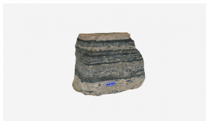
Click on the image below to see a virtual 3D model (sketchfab) of a gneissic hand sample.
Description of Thin Sections
The sample used for the shown thin section (VLS-21-500) represents a felsic portion of the high grade metamorphosed rocks at Burleigh Falls. The plane polarized light (PPL) shows bands of larger colorless minerals alternating with bands of finder crystallized minerals that vary between colorless and dark green-brown.
This corresponds to the cross polarized light (XPL) view, in which large irregularly shaped minerals (anhedral shape) with low interference colours, light to dark grey to beige/yellow (beige color = thin section slightly to thick), can be spotted in bands trending from the lower left to the upper right corner.
The XPL view also nicely shows the mix of finer crystallized minerals of irregular shape with low interference color (light grey, dark grey, yellow, beige) compared to minerals of high interference colors (yellow, green, blue, purple) that are elongated or flakey in shape. Some of the irregularly shaped light to dark minerals in the thin section show a cross-hatch (tartan) twinning pattern in XPL. Additionally, many of the larger anhedral yellow – grey minerals show an irregular color pattern of undulose extinction. The irregular (anhedral) shape of low interference color minerals, also described as embayed, stems from static recrystallization of these minerals due to high pressure and temperatures during metamorphism. Other optical properties visible are lamellar (polysynthetic) twinning of light to dark grey minerals as well as evidence of sericitization (alteration to sheet minerals). Some of the larger minerals (yellow-grey) that show evidence of undulose extinction also show inclusion trails. In places where grey-yellow minerals that show undulose extinction are in contact with grey minerals with either smooth surface texture or polysynthetic twinning, myrmekites may be seen (lower right corner).
Go to the next chapter: CMB 2 – Highway 44!

