3.3 The Seafaring World of the 15th and 16th Centuries
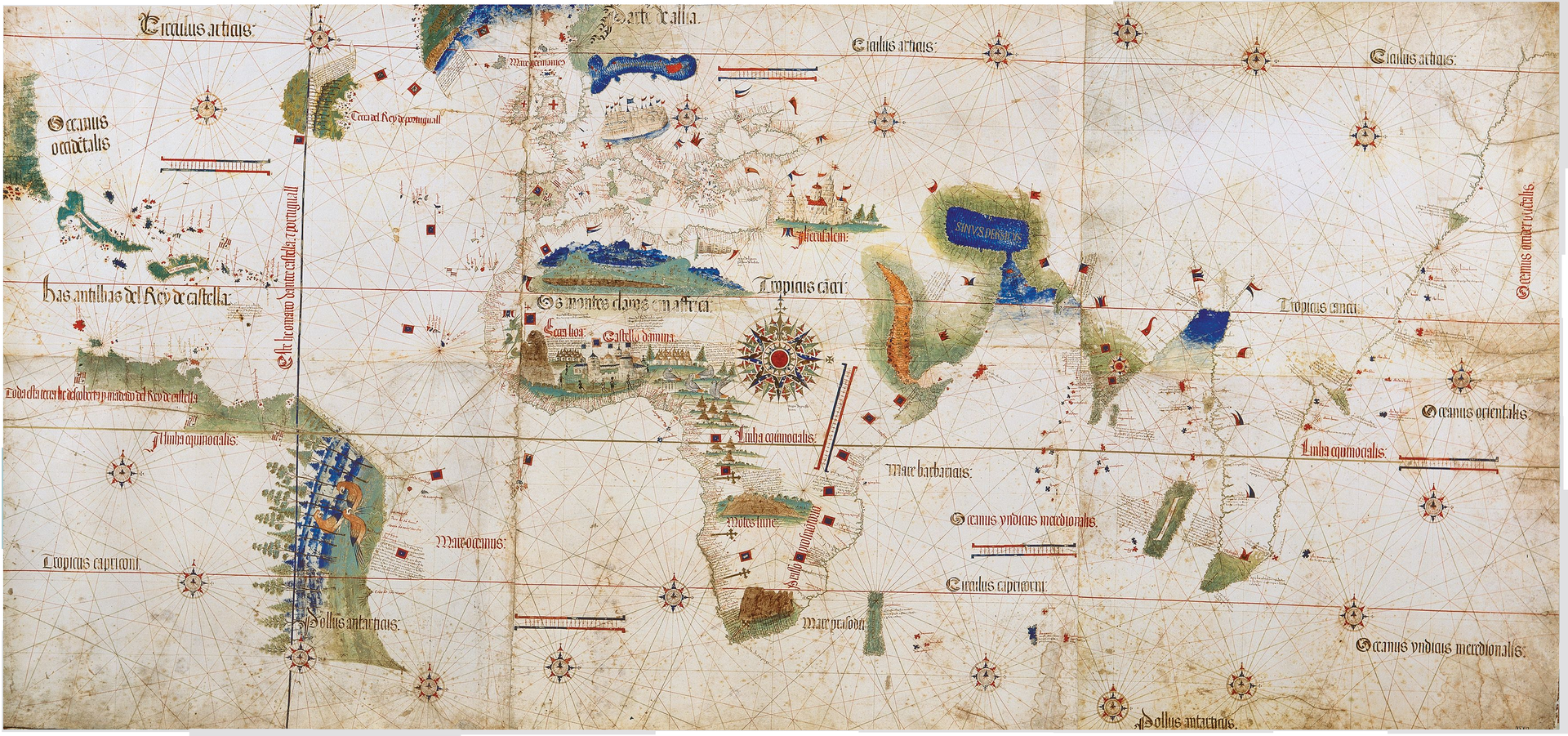
A map of the world in 1400 reveals a patchwork of small countries and kingdoms, most of them heavily centralized, but few of them truly expansive. There are exceptions, such as the Grand Duchy of Lithuania (and its successor state, the Poland-Lithuanian Alliance), which extended from the Baltic to the Black Sea, and the Ottoman Empire, which included all of the Balkan Peninsula and what is now Turkey. China’s borders under the Ming Dynasty, although huge, were a fraction of what they had been under the Mongol and perhaps a fifth of their size today. Absolutist monarchical regimes with powerful religious institutions were globally the norm. In this respect, the Aztec Empire was hardly different from its contemporaries headquartered in Beijing, the Mali Empire in west Africa, or 15th century England under Henry Tudor. A few of these nations, however, had begun exploring the possibility of expanding trade networks by sea.

The early leader in economic expansion was the Ming Dynasty under the admiralship of Zheng He (1371-1433). His fleet was one of the largest the world would see for many years, and his flagship was the largest vessel on the planet — one that dwarfed European craft. In the first half of the 1400s, Zheng pushed the maritime boundaries of Ming influence all the way to the east African coast: Chinese dialects were becoming rooted in every port town around the Indian Ocean, and piracy was virtually extinguished by Zheng’s naval policing.
Around the same time, Portuguese navigators began pushing into the South Atlantic, inching one degree of latitude a year farther south from about 1450 onwards. To put this in perspective, official European maps in the first half of the 1400s extended the world no farther south than Morocco. Africa was, apart from its Mediterranean flank, virtually unknown to Europeans. By 1488, advances in navigational instruments like the compass and the astrolabe, better ship design (like the caravel), and growing confidence allowed the Portuguese to round Cape Horn and enter the Indian Ocean. Three maritime traditions — that of Portugal, the Ming Dynasty, and the Arab ports — were now in contact. With gold pouring into Lisbon, other European nations took note. Spain in particular wanted a piece of the action but could never assert quite enough power over the Portuguese fleets to break through that monopoly around west Africa. That left the Spanish, for the time being, with only one direction in which to look.
Spain in the Americas
The year 1492 is a watershed in human history. The changes it brought to the Americas (which we explore in some detail in Chapter 5) were far-reaching and we still can feel the effects today. In Europe, 1492 had significant economic repercussions as well, as Spanish expeditions secured huge bounty in the form of precious metals. In the space of two generations, port cities that faced the Atlantic were booming. Navies grew to monstrous size, as did the industries that supported them — everything from making sails to producing dyes for uniforms to twisting enormous lengths of rope. Merchant wealth rose on a wave of price inflation, and this emergent class of traders and manufacturers began to flex a little political muscle. At the same time, it was still the age of absolutist monarchs whose power, it was thought, derived from heaven (a concept known as the divine right of kings). This understanding of the nature of power must be understood in its particular historic context: the Spain that ventured into the western Atlantic had only very recently been transformed politically and culturally in a manner that put religious identity first.
Spain was divided since the eighth century between a Muslim south and a Christian north. The marriage of the 18-year-old Isabella of Castille to her first cousin Ferdinand II of Aragon in 1469 began a rapid process of consolidating Spain into its current shape. What was left outside the boundaries was the Emirate of Grenada, the last toehold of what had been an extensive Muslim empire across Spain and Portugal. After a decade of bitter fighting, Grenada fell to the Catholic monarchs on January 2, 1492, and the reconquista was complete. In the space of barely 30 years, Spain was transformed, and the changes had come about under the sword and the Bible of a stridently Catholic kingdom. The country was militarized, police forces were introduced, religious tolerance fell to a low ebb, and religious chauvinism ran at full tide.
One arm of this movement took the form of the Inquisition. To consolidate their victory and begin the process of “purifying” their kingdoms, the monarchs issued orders for all Jews and Muslims to make a choice: convert to Christianity or leave Spain. The newly reformed Spanish identity was thus unquestionably Christian, and all subjects of the Crown were to belong to the Catholic fold. It was in this context that Christopher Columbus (himself aggressively Catholic) received support for a voyage to the West, ostensibly in search of an avenue to India that would not trespass on Portuguese routes to the south. In 1492 when he set sail, commercial, military, and religious ambitions were in play in Spain; Columbus’s voyage was much more than a harmless geographic survey.
Three ships left Spain in September 1492 with fewer than 90 men, a year’s provisions, and a fundamental misunderstanding of the size of the Earth. Scholars all over Europe argued that Columbus grossly underestimated the distance to Asia. Columbus’s misunderstanding, along with an egotistical demeanour and demands for great personal rewards from his expedition, made him an unpopular business partner and a difficult master at sea. On October 12, 1492, with mutiny a real likelihood, the small Spanish fleet sighted an island in the chain later named the Bahamas. Columbus returned to Spain in 1493, convinced that he had reached Asia. He described a tropical paradise and brought back enough gold and other valuables to secure permission for a second voyage.
The Caribbean quickly became the base for further Spanish reconnaissance. Within 25 years, European explorers and cartographers had sketched a remarkably accurate outline of the Caribbean and the eastern coasts of North, South, and Central America. For a time, Columbus himself served as governor of “the Indies,” the name used by the Spanish for the Americas. His critics accused him of harsh rule and mistreatment of the colonists, who called him “the tyrant of the Caribbean.” In fact, Columbus was arrested and returned to Spain in chains, where he was stripped of his titles and office for misrule. Columbus went to his grave believing that his voyages had taken him to Asia. Others, however, argued that he had reached a previously unknown land mass, a “New World.”
While the Spanish were busy establishing themselves in the Caribbean, Vasco da Gama (ca. 1460-1524) had made contact with India and thus won the Iberian race to tap into the spice trade. Another emissary of the Spanish throne, Ferdinand Magellan (ca. 1480-1521), confirmed Columbus’s mathematical errors and fundamental cartographical ignorance in late 1520 when his fleet entered the Pacific Ocean. Magellan’s fleet became the first to successfully circumnavigate the globe, returning to Spain in 1525, but the voyage took an incredible toll: of the original five ships and 237 men, only one ship and 18 men survived, and Magellan was not one of them.
The first challenge to Spanish hegemony in the New World came with the Treaty of Tordesillas, which divided what the Europeans knew of the Americas between Spain and Portugal. Part of Brazil fell within the Portuguese area of claim, leading to a growing struggle for control in the region between the Iberians. Later, other European nations entered the region, creating further complications. Some, like the Dutch, took a primarily economic interest in the American hemisphere, shaping their models of colonial administration largely around trade and piracy as opposed to conquest and plantations.
Key Points
- Portugal was one of the leaders of the European “age of discovery.” The Portuguese were able to successfully navigate the open sea because of technological innovations. The Portuguese explored the coast of Africa and later established trading posts up and down the coast of West Africa. Portuguese forays into the Indian Ocean marked the beginning of a powerful sea empire.
- The Spanish followed Portugal’s lead after completing the reconquista and sponsoring Columbus’s 1492 voyage. Like the Portuguese, Columbus had the goal of reaching Asia to tap into the lucrative spice trade. Columbus instead reached the “New World,” and the Spanish found themselves exploring — and exploiting — as much as they could as fast as they could. Competition between Portugal and Spain eased with the Treaty of Tordesillas, which divided the Earth into two zones of influence.
Attributions
Figure 3.4
Zheng He’s ship compared to Columbus’s by Lars Plougmann is used under a CC-BY-SA 2.0 license.
Figure 3.5
Hochelaga village – circa 1535 – Project Gutenberg etext 20110 by Project Gutenberg is in the public domain.
