Introduction to the Central Gneiss Belt Geology
Sheila Ballantyne and Phillip Ruscica
Complex and Ancient Rocks
The rocks that make up the Central Gneiss Belt are complex! These rocks are easily observed along the significant road cuts of Highway 400, between Port Severn and Killarney Provincial Park, Ontario. The strikingly beautiful, contorted rocks are also well exposed throughout the rocky shorelines of eastern Georgian Bay, cut by large pink and white intrusions sparkling with quartz and feldspar crystals. The intricate details of these rocks are indicative of their long and varied geological history.
The rocks along the eastern shores of Georgian Bay are part of a significant craton known as the Canadian Shield. Some of the oldest rocks on earth are found here, between 2.5 to 4.2 billion years old! The Canadian Shield is made of up several large geological provinces, defined by their unique geological histories. The Central Gneiss Belt is part of one of these significant geological provinces, the Grenville.
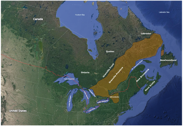
The Grenville Province exists today as a northeast-southwest trending belt, from Labrador to Lake Huron, Ontario (figure 1). Its northwestern edge is a tectonic boundary known as the Grenville Front, where the rocks of magmatic arcs and continental terranes were accreted onto the Superior Craton during an orgeny from 1190Ma (millions of years ago) to 980 Ma. The Grenville orogeny created a mountain chain that would have looked similar to what is observed today in the Himalayas. The tips of the mountains here would have 30km above the current ground-level 1.1 billion years ago! The current southeastern edge of the Grenville is an eroded surface, where much younger Paleozoic sedimentary “cover rocks” (merely 500 million years old!) were deposited. These cover rocks are predominantly limestones and are observed in southwestern Ontario and through the Niagara Escarpment today.
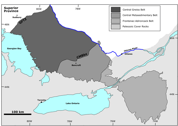
The Grenville in Ontario can be divided into three major divisions: the Grenville Front Tectonic Zone (GFTZ), the Central Gneiss Belt (CGB), and the Central Metasedimentary Belt (CMB), as shown in Figure Two (First described in Wynne-Edwards, 1972). The CMB consists of magmatic arcs and marginal basins and overlies the CGB along the Central Metisedimentary Thrust Zone (CMBbz in Figure 2). The CMB is featured in another ebook from the Virtual Petrology Network that was completed at the same time as this book.
Domains of the CGB
The CGB can be divided into several lithotectonic domains, such as Britt, Shawanaga, Parry Sound, Algonquin, Seguin, Rousseau, Moon River, Go Home, and Muskoka. For more detailed descriptions of these domains see Culshaw et al., 1997 and Carr et al., 2000. Some of the lithotectonic domains experienced more than one orogeny; some domains experienced tectonic deformation both before and during the Grenville orogeny and were thus deformed more than once. These previously deformed domains are considered “poly-cyclic”, while units showing deformation only related to the Grenville Orogeny are “mono-cyclic”.
Lithologies and Metamorphic Grades of the CGB
The protolith lithologies and ages of all the rocks in the CGB are obscured by strong deformation and high metamorphic grades. Each domain is unique in its mineral content, but in general the rocks here are upper amphibolite to granulite facies quartzofeldspathic, migmatitic orthogneisses and mafic granulites. Granulite facies is particularly interesting to geologists as it indicates these rocks were deeply buried, such as at the base of a mountain chain. The rocks are generally coarse grained, dominated by quartz, feldspars, micas (muscovite and biotite), pyroxene, hornblende, and garnets.
There are minor intrusions observed throughout the CGB. Distinct black pods are interpreted to be metamorphosed gabbroic intrusions, often with sheared contacts. Undeformed mylonitic pink and sometimes white pegmatite sheets and dykes are ubiquitous throughout the CGB.
Structure
The deformation throughout the CGB can be defined as penetrative ductile flow. Shear zones exist within domains and at domain contacts. The contacts between each of the lithotectonic domains is generally parallel to the overall Grenville Orogeny-related fabric, but not always. Strong foliation (S) and lineation (L) fabric can be observed throughout, dominantly S>=L, but orientations shift significantly in both bearing and dip. Some of these variations may be related to preserved pre-Grenvillian tectonic forces (see Culshaw et al., 1997 or Carr et al., 200 for more details).
Exemplary structural features are highlighted in later chapters in this book, including mineral lineations, mullions, rotated porphyroblasts, and boudins.
Erosion and Glaciation
Over last billion years the Grenville mountains have been weathered and eroded, removing approximately 30km from the mountain tops, leaving the smooth and relatively flat landscape we see today. This erosion gives geologists a unique window into the roots of mountains. Over the past 2 million years, several series of glaciation advanced and retreated over Ontario. The final glacier covered the CBG with more than 1km thick ice just 14,000 years ago. The ice was filled with rocks and sand, plucked and lodged from other regions as it advanced. This debris scoured and polished the ground. Glacial markings can be observed on many surfaces throughout the CGB, generally oriented to the North.
CGB Field Sites in this Book
Each site visited in this book has their general location shown in the overview map below. Click on the image to view the 3D model on Sketchfab!

Please send any comments, questions, or requests for additional information to virtual.petrology.network@utoronto.ca
References
Carr, S.D., Easton, R.M., Jamieson, R.A., and Culshaw, N.G. (2000). Geologic transect across the Grenville Orogen of Ontario and New York. Canadian Journal of Earth Sciences. 37(2-3): 193-216.
Culshaw, Jamieson, R. A., Ketchum, J. W. F., Wodicka, N., Corrigan, D., & Reynolds, P. H. (1997). Transect across the northwestern Grenville Orogen, Georgian Bay, Ontario; polystage convergence and extension in the lower orogenic crust. Tectonics (Washington, D.C.), 16(6), 966–982.
Wynne-Edwards, H.R. (1972). The Grenville Province. In Variations in tectonic styles in Canada. Edited by R.A. Price and R.J.W. Douglas. Geological Association of Canada, Special Paper 11, 263–334.
Recommended Field Guides
Davidson, A., Nadeai, K., & Culshaw, N.G. (September, 2012). CLASSIC OUTCROPS IN THE CENTRAL GNEISS BELT, ONTARIO – A RETROSPECTIVE. [Field Trip]. 43rd Friends of the Grenville Annual Field Excursion, Guidebook, Parry Sound, Ontario.
Rivers, T., & Schwerdtner, W.M. (2016). Tectonic context of km‐scale cross‐folds and foliation megaboudins in the Muskoka domain: formation in the detachment zone of a giant metamorphic core complex. [Field Trip]. Workshop of the Canadian Tectonics Group, Bracebridge, Ontario.
Schwerdtner, W.M., Klemens, W.P., Robin, P.Y.F., Vertolli, V.M., & Waddington, D.H. (2005). Field Trip Guide: Geological structure and lithology in parts of the Muskoka Region, southwestern Central Gneiss Belt, Grenville Province of Ontario [Field Trip]. 25th Workshop of the Canadian Tectonics Group, Orillia, Ontario.
Click this link to go to the overview on how to use each of the content types in this book: How to Use This Ebook
Already familiar with H5P interactions? Jump right into the book here: CGB 1 – Six Mile