142 Chapter 21 Summary
The main topics of this chapter can be summarized as follows:
| 21.1 | Geological History of Canada | The continent Laurentia, which includes what is now the Canadian Shield, was formed through the assembly of a number of smaller continents over the period from around 4 Ga to 1 Ga. Over the past 650 Ma, Laurentia moved north from deep within the southern hemisphere. During that time, a number of important plate-tectonic events have taken place, including formation of the Appalachian and Innuitian fold belts, sedimentation within the interior of the continent, and terrane accretion and mountain formation along the west coast. |
| 21.2 | Western Canada during the Precambrian | The two oldest parts of the Canadian Shield in western Canada are the Slave and Superior Cratons, and both include some of Earth’s oldest rocks. During the formation of Laurentia, these cratons were combined with the Rae and Hearn Cratons, with the collision zones now represented by the Trans-Hudson Orogen and the Taltson Magmatic Zone. Continental sediments accumulated in Saskatchewan and Nunavut at around 1,700 Ma and in the area of the southern B.C.-Alberta border at around 1,400 Ma. This region was rifted apart during the breakup of the supercontinent Columbia, after which sedimentation continued on the western margin of Laurentia with the deposition of the Windermere Group. |
| 21.3 | Western Canada during the Paleozoic | Sedimentation on the west coast of North America continued into the early Paleozoic, and by the Ordovician, the Western Canada Sedimentary Basin (WCSB) had developed, extending from southern Manitoba to the northern Northwest Territories. Most of the Paleozoic rocks in this basin, which range in age up to the Carboniferous, have marine affinities, although there are important evaporites as well. Sedimentation continued on the west coast through this time, but by the late Paleozoic, a subduction boundary had developed along the coast and small continents were moving toward North America. |
| 21.4 | Western Canada during the Mesozoic | The various parts of the Intermontane Superterrane began colliding with the west coast of North America during the Jurassic (~180 Ma). This started the building of the Rocky Mountains by the thrusting of existing sedimentary rocks toward the east. The arrival of the Insular Superterrane during the Cretaceous (~90 Ma) contributed to further thrusting and uplift of the Rockies, creating a significant source of sediments for the WCSB. The greatest volume of Mesozoic rocks in the basin are of Upper Cretaceous age, and that likely coincides with the period of maximum collision-related uplift of the Rockies. Subduction of oceanic crust at various locations along the west coast and within the accreted terranes prior to their arrival has produced massive volumes of intrusive igneous rocks within the Coast Range. |
| 21.5 | Western Canada during the Cenozoic | The Pacific Rim and Crescent Terranes were added to the western edge of Vancouver Island during the Paleogene, pushing the island closer to the mainland and forcing recently deposited Nanaimo Group rocks onto the island. Continuing subduction along the coast has generated ongoing volcanism and earthquake activity in southwestern B.C. Sedimentation continued in the WCSB into the Cenozoic, especially in the Paleocene with deposition of the terrestrial Paskapoo Formation in Alberta and similar rocks in southern Saskatchewan. |
Questions for Review
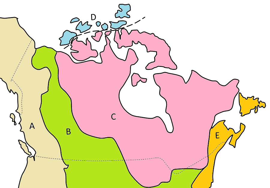
1. What are the oldest parts of Laurentia?2. The five main geological regions of Canada are shown on this map. Name the regions A through E.
3. Which ancient continent collided with North America to form the Innuitian fold belt, and when did that take place?
4. Explain why the ancient sedimentary rocks of the Athabasca and Thelon Basins are generally unmetamorphosed and undeformed.
5. Explain why ultramafic intrusions, like those of the Muskox Intrusion, are relatively common in Archean rocks, but rare in Phanerozoic rocks.
6. Use the Internet to find out why Cambrian marine organisms are so well preserved in the rocks of the Burgess Shale of British Columbia.
7. The Prairie Evaporite Formation overlies marine carbonate rocks of the Winnipegosis Formation and is overlain in turn by marine carbonate rocks of the Dawson Bay Formation. What type of changes might have led to the accumulation of evaporites during this period of marine deposition?
8. What features of the Intermontane Superterrane have been used to indicate that these rocks formed south of the equator?
9. What is the connection between terrane accretion on the west coast and the relatively rapid accumulation of sediments within the WCSB?
10.Why is the WCSB considered to be a foreland basin during the Mesozoic?
11. The four main terranes of the Intermontane Superterrane are Cache Creek, Quesnel, Stikine, and Yukon-Tanana. Referring to Figure 21.14, determine the order in which these terranes are likely to have reached North America.
12. The presence of Nanaimo Group sedimentary rocks far inland and at relatively high elevations on Vancouver Island is attributed to the accretion of the Pacific Rim and Crescent Terranes. What is the likely connection?
13. Referring to the diagram in Exercise 21.5, explain why the Paskapoo Formation gets thinner toward the northeast.

