Module 1: Historical Geography & Critical Cartography
Lesson 1.1: Discovering Mi’kma’ki/Acadie/Nova Scotia
Introduction
Welcome to Acadie… or is it Mi’kma’ki… or Nova Scotia?
As we hope you will find as you progress through these modules, this is a question without a straightforward answer. From the first day that Europeans set foot in the region, its identity has been disputed and contested. For the Mi’kmaq, who have lived in this place since time immemorial, it has never ceased to be Mi’kma’ki. For French colonists, who called this place home for several generations before their forced removal from their farms, this place came to be known as Acadie. For the English, who first made a claim to this space under European law in 1621, this place was called Nova Scotia.
Since the early 17th century, French and English interests have fought over the region. On three separate occasions during the 17th century, in fact, the English claimed nominal jurisdiction. Neither empire, however, was invested in the region significantly enough at this point to make a deep and lasting impression. After 1632, France worked to establish settlers in the Kespukwitk region of Mi’kma’ki, at the place they called Port Royal. This settlement grew slowly and, between 1654 and 1667, while the English held the small settlement, it grew and developed more or less independently from France. It was only in the 1680s and 1690s that France began to take more serious interest in the colony, issuing land grants and expanding its administrative purview. In addition to population growth at Port Royal, Acadian families moved away from this initial settlement, founding new communities at Beaubassin and Minas.
Tensions between England and France continued through the final decades of the 17th century, with English attacks on Acadie increasing in frequency during the early years of the 18th century. In 1710, Port Royal was successfully captured by the British. In the 1713 Treaty of Utrecht, the British – as the English were known after 1708, following their union with Scotland – claimed mainland Acadie, while the French continued to claim the Mi’kmaw districts of Unama’kik and Epekwitk. During all of this fighting and diplomatic discussion, neither European kingdom directly engaged with the Mi’kmaq on the subject. Upon notice of this handover decision, Mi’kmaw leaders were upset that European powers would take such actions without their consent. Combined with events in Europe, their resistance made the middle of the eighteenth century one of the bloodiest periods in the region’s history.
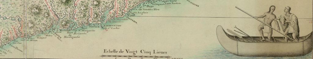
In this lesson, we will introduce you to the 18th-century world of Mi’kma’ki/Acadie/Nova Scotia using ArcGIS StoryMaps. Through this mapping tool, and looking at two mid-18th-century primary sources, we will show you the landscape across which many of these histories took place.
Learning Outcomes
By the end of this lesson, you should be able to:
- Identify the basic geography of and important locations in Mi’kma’ki/Acadie/Nova Scotia.
- Identify key aspects of Mi’kmaw, Acadian, and British histories in this region.
- Understand the basic functionality of maps that use the ArcGIS Online platform.
Technologies used in this lesson
ArcGIS
- ArcGIS is a digital mapping tool. In this lesson, you’ll not build a map, but simply examine some material thorough an existing StoryMap. In lesson 2.1, you’ll begin building one on your own.
Instructions
The activities in this lesson are embedded in a story map available on ARCgis online. Open our story map in a new window.
Conclusion
This module used historical GIS to demonstrate to you the power of digital mapping and the opportunities that GIS software provides for helping you imagine the past. The place that we are studying in this course was not understood in a singular way during the eighteenth century. Mi’kmaq, Acadian, French, English/British, and many others saw this places through very different eyes. With this in mind, we can use documents like the two you read here to help better represent these diverse realities, while also helping to better situate you – as students new to this time and place – into the geography of Maritime Canada.
