17 Country Project
| Level | Material |
| A2 and up | flipchart paper
old magazines scissors glue markers handouts (at the end of this chapter) |
Note: Teachers may choose to use all the tasks suggested or select some of them.
Task 1: Take a sheet of flipchart paper to class and post it on the board. Tell students they will create a country. The first step is to draw the outline of the country. Call a student to come to the board and draw a line on the flipchart paper. Tell him/her to stop and invite another student to continue the line in any way s/he wishes. As soon as s/he draws just a little bit, call other students to continue until you have the outline of the country finished. Have some markers ready and continue to invite students to add geographical features such as mountain ranges, rivers, lakes, a volcano, a rainforest, and so on. You can also ask students to suggest other geographical features (such as, farmland, a swamp, a desert, etc.) and ask students to draw them on the map. Next, invite some students to draw lines dividing the ‘country’ into regions. The number of regions can vary. It is a good idea to have as many regions as the number of groups you would like to form. Then, ask students to mark where each region’s main city is on the map.
Invite students to suggest answers to the following questions:
- Is our country in the southern or in the northern hemisphere?
- In general, what’s the weather like?
- Is there a coast line?
- Where is the capital city? In which region?
- What’s our country’s name?
Task 2: Divide the class into groups and assign a region to each group. Cut the map so that each group receives one region. Have each group draw any further geographical features they wish to include in their region. When students have finished working on their region, glue the region cut-outs back together to form the map of the country and affix the map to the wall.
Task 3: Give each group another blank sheet of flipchart paper, glue, pairs of scissors, and old magazines. Tell them they have about 15 minutes to look through the magazines and cut out pictures they can use to make a poster for the main city of their region. Then, give them some time to paste the pictures on the flipchart paper. Ask students to write words in the blank spaces around the pictures that tell something about their city, using the pictures as prompts (examples: fun, nice, big, beautiful, desert, farms, huge zoo, friendly, restaurants, comfortable hotels, sandy beaches, etc.).
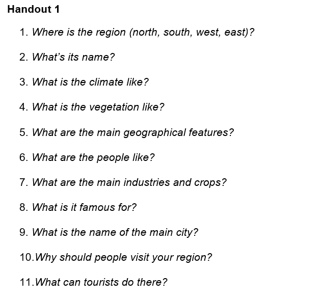
Based on their poster and the vocabulary items they wrote down, ask students to prepare a presentation about their city/region. Distribute the following handout (adapt the questions to the level of your class) and have them answer the questions accordingly. Have students present their region to the rest of the class.
- Where is the region (north, south, west, east)?
- What’s its name?
- What is the climate like?
- What is the vegetation like?
- What are the main geographical features?
- What are the people like?
- What are the main industries and crops?
- What is it famous for?
- What is the name of the main city?
- Why should people visit your region?
- What can tourists do there?
Task 4: After having students present on their city/region, ask each group to prepare a flier advertising their region.
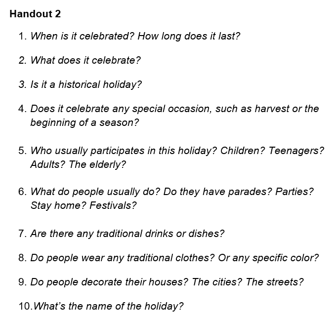
Task 5: Tell students to think about the questions below and make up a holiday for their region. Students should be prepared to describe it to other groups.
- When is it celebrated? How long does it last?
- What does it celebrate? Is it a historical holiday? Does it celebrate any special occasion, such as harvest or the beginning of a season?
- Who usually participates in this holiday? Children? Adolescents? Adults? The elderly?
- What do people usually do? Do they have parades? Parties? Stay home? Festivals?
- Are there any traditional drinks or dishes?
- Do people wear any traditional clothes? Or any specific color?
- Do people decorate their houses? The cities? The streets?
- What’s the name of the holiday?
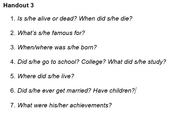
Task 6: Tell students that they are going to create the biography of a very famous and prestigious person in their region. An alternative is to prepare a “Who’s Who” file. In this case, you may wish to place students in groups or have them work individually to produce the bio of a famous person in the country. Make a list of possible people and allow students to choose one. For example: a famous writer, a famous athlete, a famous singer, etc. Give each group the handout below with questions to help develop the bio (teacher should adapt the questions to the level of their class).
- Is s/he alive or dead? When did s/he die?
- What’s s/he famous for?
- When/where was s/he born?
- Did s/he go to school? College? What did s/he study?
- Where did s/he live?
- Did s/he ever get married? Have children?
- What were his/her achievements?
Task 7: In groups, have students make a poster advertising an important touristic attraction in their country. Have students present and advertise the touristic attraction.
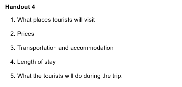
Task 8: In groups, have students organize a tour package somewhere in their country. Give each group the handout below with questions to help develop the package (teacher should adapt the questions to the level of their class).
- What places tourists will visit
- Prices
- Transportation and accommodation
- Length of stay
- What the tourists will do during the trip.
When the groups have finished preparing their tour packages, have one member from each group visit another group and role-play getting information about the tour. When the role-play is finished, students return to their original groups and report on the tour they have learned about.
Task 9: In groups, have student prepare a brochure for their country using the information they developed during the previous tasks. You may assign different parts of the brochure to different groups (e.g., geographical features, main cities, economy, weather, holidays/events, who’s who, etc.).
Handouts (Photocopiable)
————————————————————————————————————————————-
————————————————————————————————————————————-
————————————————————————————————————————————-

Feedback/Errata