Lab 5.2: Fluvial System Analysis
Introduction
This lab will have you examine a fluvial system on McMaster’s campus: Coldwater Creek in West Campus, which is located by Parking Lots M and P. You will be asked to perform some basic calculations of the channel planform, and interpret human impacts on the creek. In addition, you will be asked to compute basic hydraulic and sediment transport calculations on Coldwater Creek based on existing measurements that will be provided to you.
Tasks
1) Site Analysis (25 pts)
To get started, download the associated Lab5.kmz file from Avenue to Learn and open it in Google Earth. You should see a stop indicating the location of Coldwater Creek in West Campus.
a) Investigate the area surrounding Coldwater Creek. Describe what human activities likely impact the geomorphology of this river (3 pts).
b) Would you interpret the current river path as the original path, or has it been modified? Provide a justification for you answer (3 pts).
Choose a sub-reach of Coldwater Creek approximately 100 m in length between Osler Dr. and its downstream end where it joins with Spencer Creek. This will be your study reach. Remember you can use the historical imagery tool to find imagery with the best view of the creek.
c) Create a labelled map of your study reach (7 pts). You can export your map as an image and edit it in another program (Word, PowerPoint, Adobe) to add labels and arrows. Your map should include the following:
-
- The upstream and downstream end of your study reach
- The flow direction with a labelled arrow
- Any major Infrastructure present (e.g., bridges, roads, parking lots, etc.) with appropriate labels
- A north arrow
- A scale bar
d) From the upstream to downstream end of your study reach, measure the reach length (Hint: reach length is calculated along the channel centerline) (2 pts), and calculate the channel sinuosity (3 pts). Show your work.
f) Indicate on your map (with an arrow, line, or polygon), where you interpret the river floodplain to extend based on clues in the landscape (2 pts). What type of flood hazards do you foresee in this area? (2 pts).
2) Hydraulic and Sediment Transport Calculations (20 pts)
A group of students came out to Coldwater Creek during a flood and took measurements of the channel slope, cross-section, and sediment size. A set of velocity measurements were also taken at the centre of the channel. The data they collected is provided below (be aware of the units!). Using this data,
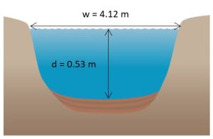
a) Calculate the hydraulic radius (Hint: You can assume the cross-section is approximately rectangular) (2 pts).
b) Calculate the mean flow velocity using two methods:
- The flow measurements (2 pts)
- The Manning equation. (3 pts)
For this exercise, you may choose to estimate the Manning’s n coefficient from a table (be sure to justify your choice) or from the empirical equation based on the median sediment diameter. Be sure to list which method you used.
c) Calculate the discharge (2 pts).
d) Determine whether the flow is laminar or turbulent (3 pts).
e) Determine whether the flow is subcritical or supercritical (3 pts).
f) Determine whether the median sediment size will move under these flow conditions (5 pts).
Channel slope: 0.00426
Median sediment diameter: 2 mm
Cross-section survey:
Flow velocity measurements:
|
Depth of measurement from water surface (m) |
Velocity (m/s) |
|
0.05 |
1.51 |
|
0.07 |
1.48 |
|
0.1 |
1.48 |
|
0.13 |
1.46 |
|
0.18 |
1.45 |
|
0.2 |
1.42 |
|
0.24 |
1.40 |
|
0.29 |
1.36 |
|
0.32 |
1.33 |
|
0.36 |
1.31 |
|
0.41 |
1.26 |
|
0.44 |
1.18 |
|
0.49 |
1.12 |
|
0.53 |
0.95 |
